KNOW YOUR RISK
FLOOD FACTS
Flooding is one of the fastest-growing threats in Hampton Roads, and it often strikes where people least expect it. Understanding the facts about local flood patterns and your property’s risk isn’t just smart, it’s essential. Knowing your flood risk now gives you the power to prepare, protect your home or business, and avoid devastating losses when the water comes.
FACTS ABOUT HAMPTON ROADS AND FLOOD RISK
Floods are the most common natural hazards.
And we’re not alone… Ninety percent of all natural disasters in the U.S. involve some type of flooding.1, 2 But not every flood is catastrophic. Smaller, more frequent flooding degrades infrastructure and can damage roads and building foundations over time. Communities suffer school closures, traffic interruptions, and continuing cost and inconvenience due to this “nuisance flooding.” 3
Anywhere it can rain, it can flood. Period.
There are many causes of flooding here in Hampton Roads, and rainfall is one of them. High-risk areas, including parts of Hampton Roads, have a one-in-four chance of experiencing a flood over the life of a 30-year mortgage.
High-risk areas, including parts of Hampton Roads, have a one-in-four chance of experiencing a flood over the life of a 30-year mortgage.1
Heavy rainfall events have become more intense and frequent in our area and will only continue to increase.2 Based on previous records, it is also likely that water levels will be higher than the average daily high tide when a rainfall event occurs.3
The total annual rainfall in our area has trended up over the past 70 years from about 43 inches to nearly 50 inches.4

Data Source: Precipitation data for 1946-June 2025 for Norfolk International Airport, VA (GHNCD: USW00013737), NOAA National Centers for Environmental Information
Hurricane Matthew in 2016 was the most costly flood event in Hampton Roads in recent history. Nearly 2,000 (1,936) NFIP claims were paid to Hampton Roads residents following the event totalling nearly $62 million ($61,871,675). Twenty-nine percent of the claims made were outside of mapped Special Flood Hazard Areas (SFHA).

This chart shows the percentage of NFIP claims that were made for properties outside of Special Flood Hazard Areas by year in Hampton Roads. Redacted claims data downloaded from OpenFEMA September 2025.
In Hampton Roads, we are surrounded by water.
Waterways permeate every corner of Hampton Roads, making it especially susceptible to flooding. No matter where you are in Hampton Roads, it would only take about 15 minutes to walk to a stream, river or body of water that flows into the Chesapeake Bay.1
We live just a few feet above sea level.
We’re so fortunate to be living in beautiful Hampton Roads. But sometimes, all the water that’s a tremendous source of business and pleasure here in coastal Virginia can become a big problem. But this is not just about whether you live on or near the water (the oceanfront or the bay, near a river or lake) or even if your neighborhood’s already experienced flooding from overwhelmed drainage systems or not. This is about the fact that if you live in Hampton Roads, you are at risk of flooding.

Graph of number of building footprints in the 100-year floodplain as of September 2025. Counts were determined using building footprints from VGIN 2025 Q2 product and FEMA National Flood Hazard Layer.
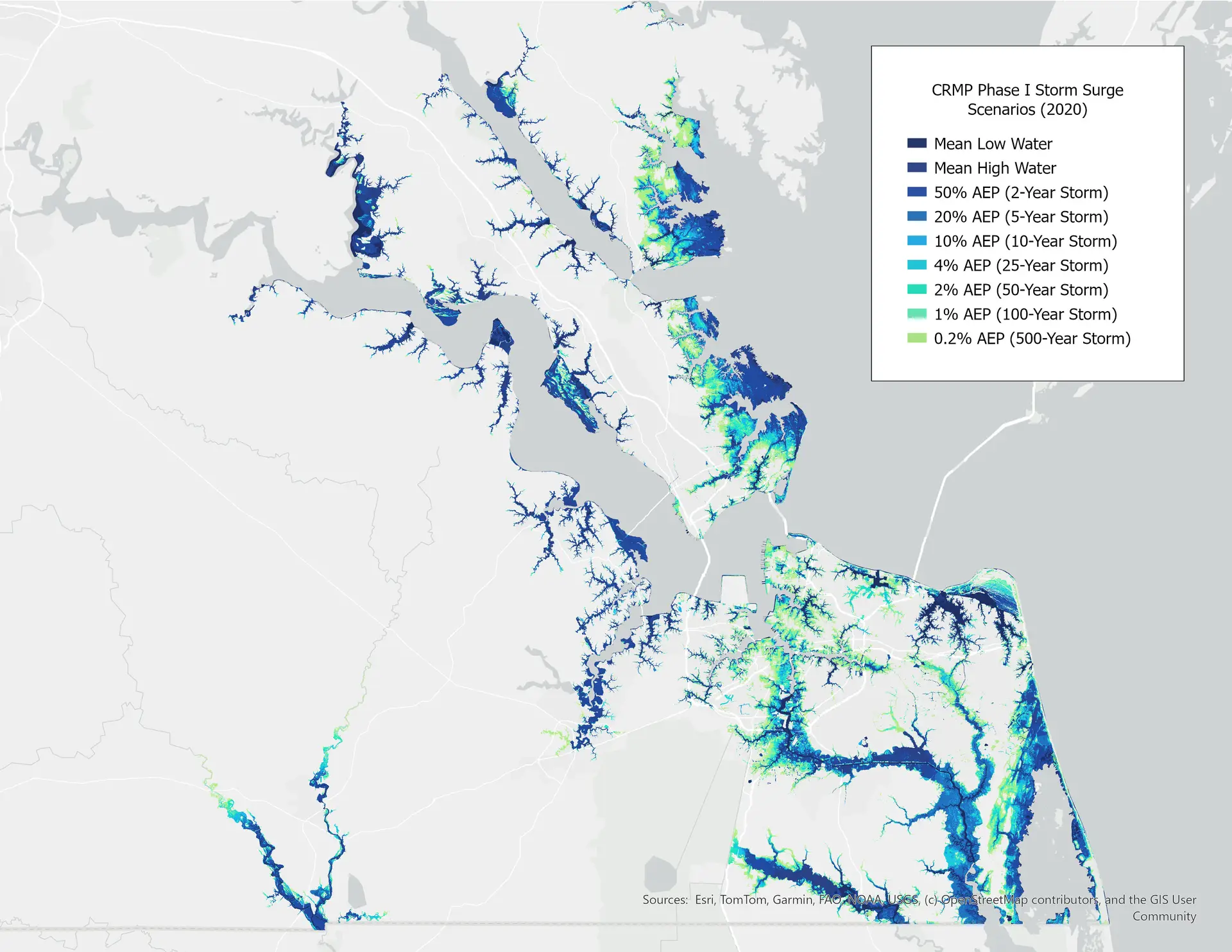
We’re vulnerable to storm surge.
With so much water and such low ground, Hampton Roads is especially vulnerable to storm surge, the abnormal rise in seawater level during a storm caused primarily by winds pushing water onshore. Even “low risk” areas are at substantial risk of flooding during large storms.
Our sea level is rising.
In Hampton Roads, the sea is rising by one inch every five years; in the last 25 years, sea level has risen here by over five inches.1 Scientists now forecast that in the next 30 years, sea level will rise by over a foot.2 Doesn’t sound like much? Consider this: Norfolk is flooding nearly twice as much now as in 2000 due to less than five inches of sea level rise.3
Not only is the sea level rising in Hampton Roads, but the ground here is also sinking. An extra inch or two every 20 years may not sound like much4, but that’s the reason Hampton Roads is experiencing the highest rate of sea level rise on the East Coast. It’s a one-two punch combination that floods will increasingly affect more territory and homes in our region’s cities, even during high-tide events without major storms.5

Source: NOAA Sea Level Calculator – Observed Sea Level Trends for Sewells Point, VA
Hampton Roads is sinking.
Not only is the sea level rising in Hampton Roads, but the ground here is also sinking. An extra inch or two every 20 years may not sound like much1, but that’s the reason Hampton Roads is experiencing the highest rate of sea level rise on the East Coast. It’s a one-two punch combination that floods will increasingly affect more territory and homes in our region’s cities, even during high-tide events without major storms.2
Source: NOAA Sea Level Calculator – Observed Sea Level Trends for Sewells Point, VA
FACTS ABOUT FLOOD DAMAGE & INSURANCE
The damage from just one inch of water can cost thousands of dollars.
The average flood insurance claim in Hampton Roads? $29,800.
From 2014 to 2024, there were over 4,000 (4,096) NFIP claims paid in Hampton Roads totalling over $122 Million ($122,057,473). The average flood insurance claim in Hampton Roads from 2014 to 2024 was $29,800.1
Low-risk does NOT mean no-risk.
Statistics show that people who live outside high-risk areas file more than 25 percent of flood claims nationwide.1 Take, for example, the devastation of Hurricane Matthew in October 2016; of the Hampton Roads households that were impacted, 84% were outside high-risk mapped flood zones.2
Are you willing to risk your home and its contents? Use FEMA’s Nation Flood Insurance Program estimator tool to get a quick estimate of what your flood insurance rate might be.
Homeowners and renters insurance does NOT cover flood damage.
Fifty-six percent of homeowners with homeowners insurance believe their policy covers flood insurance.1 If you are unsure, check with your agent.
Flood insurance pays whether or not federal disaster assistance is available.
Federal disaster assistance is only available after a Presidential Disaster Declaration.1 What’s more, even if a Presidential Disaster Declaration2 has been made, the money offered through disaster assistance is typically a low-interest loan that will need to be paid back, and if you do qualify for a grant, it will most likely provide much less than you would need to recover.3
Get started protecting yourself!
Use FEMA’s Nation Flood Insurance Program Quoting Tool to get an estimate of your flood insurance cost.

